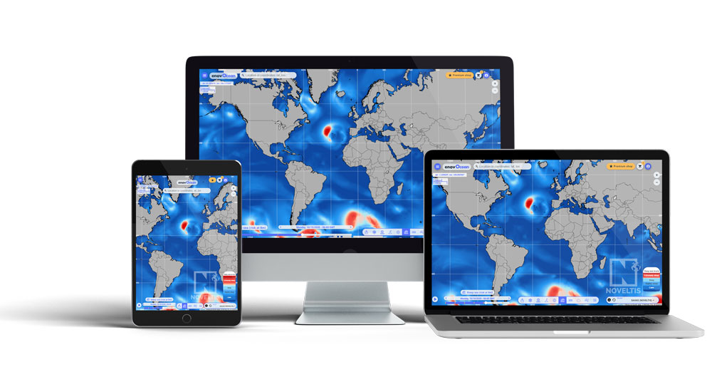
enovOcean is a user-friendly-high-precision professional tool for marine weather forecast
This e-platform provides a worldwide vision of the weather and marine risks evolution, and it makes it much easier to understand your own local situation.
Beyond the usual parameters (wind, wave, currents…), it provides unique indicators in the Premium Shop: rogue waves, steep sea, model comparisons, tidal currents…
You can now buy an access to your metocean data online and retrieve the information just when you need it, saving time and money.
This was made possible because NOVELTIS brings more than 20 years of experience observing and modelling wind, sea-states, currents and associated risks.

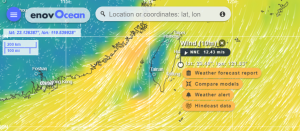
enovOcean wind map showing a tropical storm approaching Florida
Premium products details
Hindcast data
NEW! 30 years of hindcast data on wind and waves available worldwide upon a few clicks on enovOcean.com.
Before you purchase a comprehensive metocean study on a particular site, you might want to get some preliminary metocean indicators. enovOcean provides useful wind and waves time series over 30 years of history, on any sea in the world. Select a point of interest, and then purchase some credits online to get your data quickly.
The data you get has already gone through advanced statistical processing by NOVELTIS and is ready for use, with tables of return, of occurrence… as well as wind and waves roses. It comes as a downloadable PDF or a CSV file. You may also buy the raw data as a CSV file.
It is ideal preliminary information for offshore activities, heavy lift, towing, commissionning and decommissionning… to characterize a site and perform first assessments.
Hindcast data in the south-east of China on enovOcean
Wave risk products
This package offers an access to a large set of risk animated maps, providing unique information on the dangerousness of sea state conditions, with 7-day forecasts that are updated every 6 hours. Advanced indicators such as crossed sea, rogue waves and steep sea are provided globally or at fine scale resolution.
The sea state conditions provided by NOVELTIS at fine-scale are produced by the SAVaS operational system of NOVELTIS, including the most advanced forecasting technologies.
The SAVaS system was developed with the support of the General Direction for Armament in France and validated by the French Navy. Seven-day forecasts are produced at different spatial and temporal scales and are updated every 6 hours.
The information delivered by SAVaS is reliable, accurate, fast and easy to use.
Sea-state conditions are produced based on both the state of the art of wave modelling and wind forcing parametrization.
Downscaling (down from 1degree to 2 minutes) allow to improve sea state forecasts when focusing on an area of interest for particular marine activities like:
- Towing fragile objects
- Secure and protect people, vessels and infrastructures from the unusual sea state conditions
- Provide a decision-making support for operations planning
- Ensure a continuous monitoring of the sea state and its risks
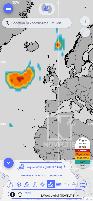
enovOcean map of rogue waves in the North Atlantic
Fine scale Metocean products
This package offers an access to very fine-scale meteocean forecasts down to 3,5 km of spatial resolution. The fine-scale forecasts are provided for the 7 coming days and are refreshed every 6 hours.
Below are some examples of regions provided at fine-scale:
- North-West Africa (resolution: 15 km)
- South-West Africa (resolution: 15 km)
- South America (resolution 15 km)
- Uruguay (resolution 7km)
- Cape of Good-Hope (resolution 3,5 km)
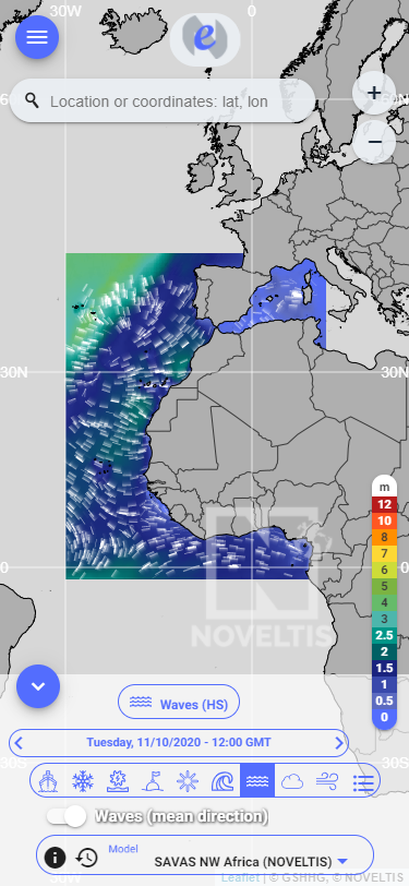
enovOcean high resolution wave map for North East Africa
Observations and models inter-comparisons
This package provides a unique access to a large set of satellite and in-situ observations over all maritime areas, as well as to unique inter-comparisons between the different models that are available. It can also compare the models and the actual observations. The inter-comparisons allow to assess the accuracy of each forecasting model and help the users to decide which forecasting model is the most appropriate for planning their operations at sea.
You can assess the accuracy of sea state forecasts, then decide and plan operations at sea, thus reducing technical, human, material and environmental risks. This package constitutes an on-line solution that brings together all the information on the metocean conditions and provides the user with a wealth of comprehensive information for decision-making.
This package provides an operational support to all stakeholders in the maritime industry for the planning and optimization of their activities at sea. It is particularly useful for shipping and offshore activities.

Excellent correlation between our SAVAS wave model in light blue with the in-situ observations from the buoys.

Very good correlation between our SAVAS wave model in light blue and the satellite measurement.
Marine renewable energy
Our Marine Energy Products offer a unique access to several crucial information, allowing to identify areas for the development and the installation of devices using tidal energy. Our marine energy products are available on the coasts of the whole world.
Our Marine Energy Products constitute a real decision-making tool to identify and characterize the most suitable sites for the development of tidal energy.
These unique products are generated by the TidEA system of NOVELTIS that covers all global coastal regions and provides data up to 100 meters deep. For each selected site, our system provides information on the maximum current speeds, the energy potential and the speed threshold occurrence indicators.
The information provided in our Marine Energy Products is validated continuously with different multi-source observations (e.g. in-situ data, elevation data…)
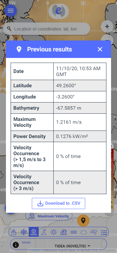
enovOcean table of results for a tidal renewable energy assessment
Other products available:
Weather forecast reports
Many outdoor activities require that you have a clear vision of the weather situation in the following days. Especially at sea, a close monitoring of the evolution of wind and waves can be absolutely crucial for your business and sometimes even for your own life.
Every activity has its own requirements. That is why we have decided to offer a fully customized weather report.
Select the point for which you want a weather report, either by clicking on the map or by keying -in some coordinates.
Choose the parameters you want to follow, according to the needs of your activity. The enovOcean weather report is a professional tool, so you can select a large variety of indicators in the most important categories : wind, wave, weather, currents, sea- icing. It will be very useful for offshore activities, for marine renewable energies ( wind turbines, tidal turbines and wave converters) and for shipping, fishing and yachting. Just click on the parameters you want to follow.
A rolling 8 day horizon allows to keep a good level of reliabilty.
A user-friendly colour coding enables you to assess the evolution of the weather situation at a glance.
You may as well chose the duration of the service you wish : a week, a month, a customized period (date to date) is also possible to suit best your professional constraints.
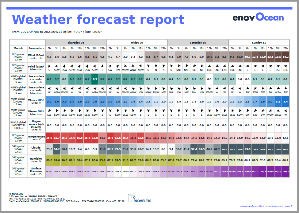
Weather Forecast report example from enovOcean
Weather alerts
If certain weather conditions can be a threat for your security or for your activity, you might want to set an automatic alert, which will prevent you from watching the forecast several times per day.
If on the countrary you need certain minimum weather wind conditions for sailing, you can also set an automatic alert that will tell you when the conditions willl be favorable.
All indicators that are available on the enovOcean.com platform can be selected for a custom weather alert.
- Wind alerts
- Wave alerts
- Pressure alerts
- Risk waves alerts (+20€/day)
- Sea ice thickness alerts
- Current speed alerts
- …
Select some coordinates, the duration and your alert is set. You will be warned by mail 2 days in advance. You will get only one warning for each event.
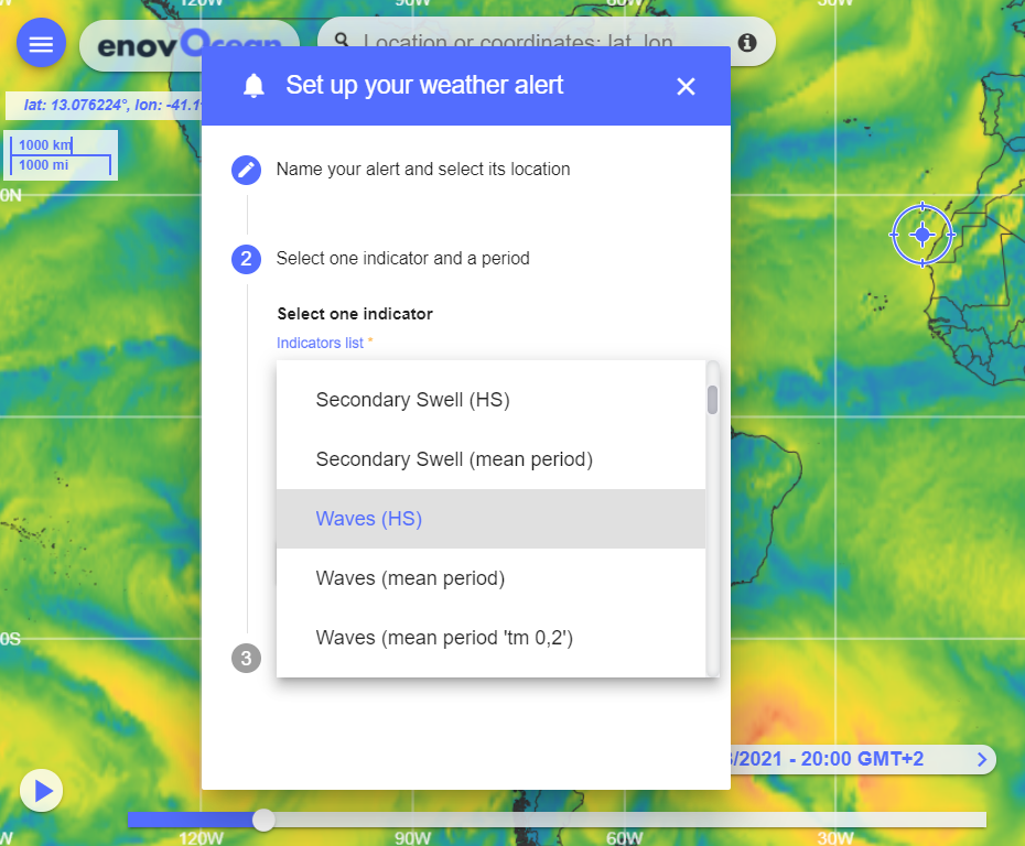
Weather alert settings example from enovOcean
Our enovOcean platform is ideal for a number of maritime activities such as:
- Shipping
- Cruising
- Yachting
- Offshore wind farms
- Offshore Oil & Gas
- Maritime insurance
- Marine renewable energy
- Fishing
- Sailing
- Surfing
- etc.
