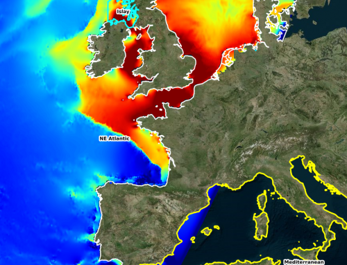
Marine Energy Atlas of Tunisia
A comprehensive online tool describing the offshore wind resources, wave and tidal power resources designed for STEG, the Tunisian electricity provider.
The marine energy Atlas in Tunisia offers the opportunity to browse through the results of numerical simulations that were conducted throughout the Tunisian coast to determine the potential for offshore wind, wave and tidal energy.
Our atlas offers also an overlay of maps and geo-referenced information coming from satellite and in situ data for describing the characteristics of the Tunisian territory.
Addressing both exclusion zones and projects economic viability, the atlas provides through a decision making tool a comprehensive and helpful answer for all stakeholders involved in the marine renewable energy projects.
Project details
Categories:
Tags:
Share this project:
Marine Energy Atlas of Tunisia
A comprehensive online tool describing the offshore wind resources, wave and tidal power resources designed for STEG, the Tunisian electricity provider.
Project details
Categories:
The marine energy Atlas in Tunisia offers the opportunity to browse through the results of numerical simulations that were conducted throughout the Tunisian coast to determine the potential for offshore wind, wave and tidal energy.
Our atlas offers also an overlay of maps and geo-referenced information coming from satellite and in situ data for describing the characteristics of the Tunisian territory.
Addressing both exclusion zones and projects economic viability, the atlas provides through a decision making tool a comprehensive and helpful answer for all stakeholders involved in the marine renewable energy projects.
Means used
Results
Innovative atlas offering the following parameters at unparalleled resolution and accuracy.