Project Description

Generating an a priori command to monitor hydrological targets elevation through spatial altimetry

In the frame of the OLTC project, NOVELTIS is in charge of elaborating Digital Elevation Model (DEM) for Sentinel-3A&B and Jason-3 altimetry missions and validating the data acquired over hydrological targets by these altimeters.

Freshwater is an essential natural resource that needs to be preserved and monitored. The quantity of available freshwater in an area is strongly related to the evolution of the level of the different water stocks there. However, installing in-situ measure means in every freshwater sources (be they natural or artificial) is not an easy task. This is where satellite altimetry has a key role to play. For many years, it has been used to monitor globally the evolution of an increasing number of hydrological stocks.
NOVELTIS is at the root of this innovative approach since its OLTC project consists in generating the most precise and optimized a priori on-board command (e.g. the DEM) for satellite altimeters. This way, the instruments, primarily meant to measure the oceans’ elevation, can keep track of the elevation of many hydrological targets (currently more than 30,000 for each Sentinel-3 mission). This on-board command is used by the instrument to grade its reception window on the a priori elevation of the target so that it is able to precisely measure the actual elevation of the freshwater stocks it passes over. The objective is to cover the maximum number of possible targets and this number has been skyrocketing.
NOVELTIS also plays a key role in the validation of the altimeter performances over hydrological targets.

Project details

Website

Categories:

Tags:

Share this project:

Contact-us

Generating an a priori command to monitor hydrological targets elevation through spatial altimetry

In the frame of the OLTC project, NOVELTIS is in charge of elaborating Digital Elevation Model (DEM) for Sentinel-3A&B and Jason-3 altimetry missions and validating the data acquired over hydrological targets by these altimeters.

Project details

Website

Categories:

Share this project:

Contact-us
Freshwater is an essential natural resource that needs to be preserved and monitored. The quantity of available freshwater in an area is strongly related to the evolution of to the level of the different water stocks there. However, installing in-situ measure means in every freshwater sources (be they natural or artificial) is not an easy task. This is where satellite altimetry has a key role to play. For many years, it has been used to monitor globally the evolution of an increasing number of hydrological stocks.
NOVELTIS is at the root of this innovative approach since its OLTC project consists in generating the most precise and optimized a priori on-board command (e.g. the DEM) for satellite altimeters. This way, the instruments, primarily meant to measure the oceans’ elevation, can keep track of the elevation of many hydrological targets (currently more than 30,000 for each Sentinel-3 mission). This on-board command is used by the instrument to grade its reception window on the a priori elevation of the target so that it is able to precisely measure the actual elevation of the freshwater stocks it passes over. The objective is to cover the maximum number of possible targets and this number has been skyrocketing.
NOVELTIS also plays a key role in the validation of the altimeter performances over hydrological targets.
OLTC Figure
Logo OLTC

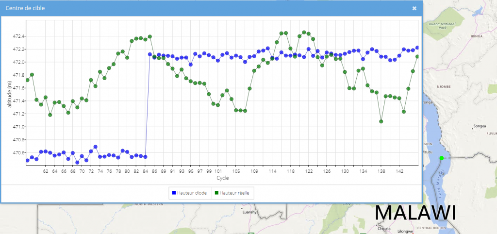
This figure shows an example of the OLTC use to monitor lakes. The blue plot represents the on-board command from the Jason-3 DEM generated by the new NOVELTIS method over Lake Malawi. The lake’s elevation practically measured by the Jason-3 altimeter is shown in green. Considering the measures from cycles 56 to 84 (first part of the plot) the a priori command over the Lake was corrected (from 470 to 472m). The altimeter is able to precisely keep track of the seasonal variations of Lake Malawi thanks to its DEM.

This on-board command takes up much memory which is a scarce resource on-board satellite altimeters. The DEM needs to be optimized efficiently so that it is compressed to its maximum. It is also of prime importance to respect the instrument constraints and to ensure the quality of the generated command.

Means used

NOVELTIS has developed and maintained an innovative method to generate and optimize the DEM of satellite altimeters, taking into account the various constraints and centralizing the information from various databases.

A specific diagnosis has also been developed to attest the correct detection of a target by the altimeter. It is currently used for performance validation purposes.

NOVELTIS has also made available the website altimetry-hydro.eu dedicated to all users wishing to contribute to the hydrological database used to generate the on-board DEM.

Results

NOVELTIS got very promising results with detection rates of hydrological targets (rivers and lakes) up to 90%. The results were so satisfactory that the SRAL altimeter of the Sentinel-3 mission is currently operated in OLTC mode.